Raster Images and 3-D Objects in Geodatabases
This project is investigating database support of raster data management within geodatabases. Visualisation is the most obvious aspect of raster data management. However, many important tasks are not concerned purely with visualisation, but are centred far more on raster data processing tasks. Examples include 3D-feature extraction (such as roads, rivers and buildings), and visualisation not of raster images, but of raster maps.
This project is investigating database support of raster data management within geodatabases. Visualisation is the most obvious aspect of raster data management. However, many important tasks are not concerned purely with visualisation, but are centred far more on raster data processing tasks. Examples include 3D-feature extraction (such as roads, rivers and buildings), and visualisation not of raster images, but of raster maps.
This project addresses the raster data management problem with particular emphasis on such processing tasks. Two specific problems are being addressed: physical database design to support raster data processing; and metadata management for extracted 3D features.
Physical database design:
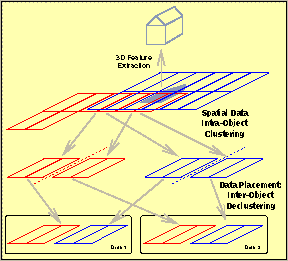
In this sub-project, we are investigating mappings of raster data sets to secondary storage devices with the aim of supporting 3D-feature extraction. Two techniques are applied: spatial data clustering and inter-image declustering.
Spatial data clustering
aims at ensuring spatially-near objects are clustered on disk for efficient retrieval. The standard raster representation does not achieve spatial clustering. The alternative of Z-ordering achieves reasonable clustering, but at the expense requiring costly re-organisation for visualisation. We are pursuing a further alternative in which raster data is tiled into rectangular regions prior to being stored. This approach has the advantage of achieving reasonable spatial clustering while limiting the reconstruction costs necessary for visualisation.
Declustering
aims at ensuring data which is likely to be needed together is placed on different disks. This ensures that they can be retrieved in parallel. For 3D-feature extraction, there are two cases in which declustering and parallel retrieval is an attractive placement strategy:
Intra-image declustering:
Within a single image, declustering the spatially-close tiles of an image reduces the length of time necessary to retrieval image parts which are larger than the tile size (including the entire image).
Inter-image declustering:
3D-feature extraction exhibits spatial locality of reference not just within a single image, but also between images. This implies an increased probability that spatially-close tiles from different images will be retrieved together.
We are studying both clustering and declustering strategies for raster images.
Metadata
The second aspect we are addressing is that of metadata management. Due to the computational costs of raster data processing, re-use of existing data is important. Databases provide an attractive management tool for such metadata, and offer improved use of metadata through query support. Development work in RasterGIS is being carrid out primarily within the framework of our in-house prototype system CONCERT.
Project Partners:
This is an interdisciplinary project being carried out together with GIS and Photogrammetry partners from the Institute of Geodesy and Photogrammetry at ETH (Professors Carosio and Grün).
Funding:
This cooperative, internal ETH project is specially-funded by ETH.
References
Lukas Relly and Hans-J. Schek and Olof Henricsson and Stephan Nebiker, Physical Database Design for Raster Images in Concert. In: 5th International Symposium on Spatial Databases (SSD'97), Berlin, Germany, July 1997.